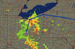
 The large hook echo on the weather radar confirmed reports of severe thunderstorms and tornadoes as we flew towards Cincinnati. The tops of the storms where lower than our maximum cruising altitude so it seemed like we would have no problem flying over the storms. All was good until we where airborne and saw how quickly the storms where growing.
My coworker was fairly new to weather flying and did not seem at all disturbed by the oncoming weather. I said we need an exit strategy in case this storm becomes so severe that we cannot fly through it. We decided our best route would be a turn to the southeast if we found that we could not pass the large line of building storms.
As we navigated our way around the storms I notice a hole but it was now closing up. Since the line behind us was closing and the one in front of us was starting to close I knew we where in for a rough ride. I picked the area with the thinnest radar returns and pointed our nose toward them. Since we where still in a climb I was hoping we would make it over the tops or at least not be in the storm for very long.
As we penetrated the thunderstorm the vertical speed indicator immediately increased to over four thousand feet per minute. The ride became rough but nothing more than moderate turbulence. Then we suddenly began to rise even faster and the airspeed began to increase to redline. I then told my coworker to call out any sudden decreases in airspeed because we where in a large updraft and to expect a sudden downdraft shortly. Having been through many storms I new the next maneuver would be to pitch the nose down and put in full power to recover before we stalled.
I had to continually pull the nose up and reduce power to keep from over speeding the aircraft. Even though it seemed like an eternity, about 30 seconds later the airspeed began to drop like a rock. I pitched the nose down and put in full power. I continued to push down on the nose but still saw the airspeed dropping, getting closer to the stall speed. As I began to push further forward on the yoke the airspeed suddenly stopped and reversed direction. “Oh good we are getting out of that down draft.” We had lost over fifty knots in my recovery and where coming very close to having the stick shaker go off.
After we landed and taxied to the gate in Cincinnati the storms began to roll over the field closing the airport. I was glad we landed before the storms hit the field. I later discovered over thirty people on the ground has lost their lives in the storm system that we just flew through.
Having knowledge of how thunderstorms develop and what to do if you find yourself inside a storm is important if you want to survive an encounter with one of these large aircraft grinding machines. So how did I know we where going to have such a large downdraft? Well lets review the weather theory behind thunderstorms.
Thunderstorms : Three Ingredients
Like baking a cake there are certain ingredients necessary for a thunderstorm to form. The first ingredient is unstable air. Second, add some moisture. Third, some type of lifting action is necessary.
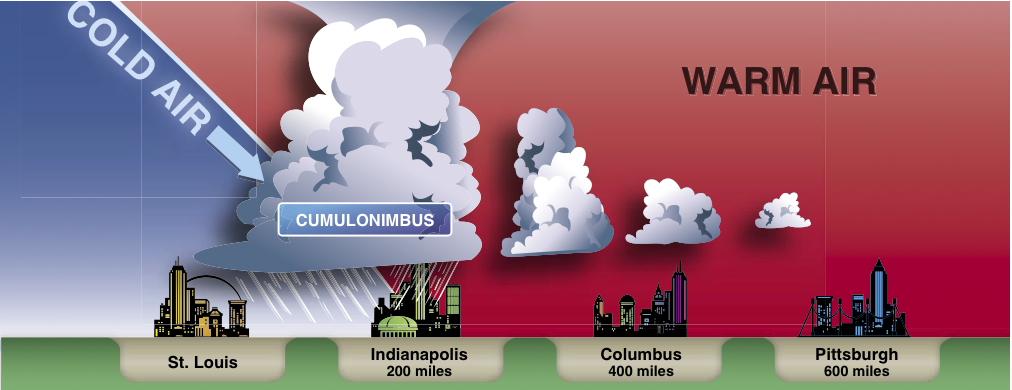
The most severe thunderstorms normally form in front of strong cold fronts but severe storms can form anywhere we have the three essential ingredients. Thunderstorms that form on their own and are not associated with a cold front are called air mass thunderstorms and can be as severe but usually don’t last as long as those associated with a cold front. Storms associated with frontal activity are normally more persistent and affect large areas of the country. These storms are referred to as steady state thunderstorms and by their name you can tell they are very persistent.
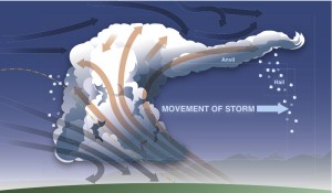
(click image to enlarge)
Hazards
Thunderstorms contain a combination of hazards to aircraft which include moderate or greater turbulence, hail, structural ice, heavy rain reducing visibility, lightning, and wind shear. If this isn’t enough to make you want to fly around a storm I’m not sure what would. But if this isn’t convincing enough lets review the hazards.
Turbulence and Wind Shear
Severe thunderstorms are natures’s aircraft grinders having caused aircraft to lose critical control surfaces and even wings. This alone is a good reason to stay well clear of these storms. If you do find yourself inside even a small thunderstorm you can encounter severe or greater turbulence. The most severe turbulence is in the shear between the updrafts and downdrafts as was the case in my flight above.
Even if you avoid penetrating a severe thunderstorm you can still experience severe turbulence. Turbulence has been encountered by aircraft thousands of feet above the thunderstorm and 20 miles laterally from a severe storm. This is a good reason to stay more than 20 miles away from storms.
Gust Fronts
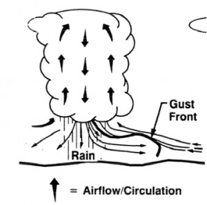
One day while waiting to take off the tower calls and says all departures are stopped because of an approaching gust front. The gust front is the air which flows outward from a large thunderstorms or line of storms and can be up to 15 miles ahead of the precipitation. At times radar can pick up the gust front especially if there is a roll cloud associated with the gust front. The roll cloud is the top of the outflow of the gust front and can be very turbulent. The best thing to do in this case is wait out the passage.
Low Level Wind Shear
Associated with thunderstorm and the gust fronts are sudden changes in windspeed and direction near the ground, called low level wind shear. The gust front and the passing of the storm over the airport causes low level wind shear both as they arrive and as they move away from the airfield.
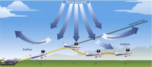
Low Wind shear due to thunderstorms are hazardous to all aircraft because the change in the wind direction and speed can dramatically affect the performance of the aircraft. Winds can change from a headwind to a tail wind and with the velocity changing 50 knots or more. If you are caught close to the ground during a wind shear event you may never be able to recover. As you can see in the picture below you don’t want to be in the position of plane number 3 trying to climb while being pushed to the ground.
(click picture to enlarge)
Microbursts
Some of the most dangerous wind shear events associated with rain showers and thunderstorms are microbursts. I’ll never forget seeing the damage done by a microburst near my home. Many large trees where blown down in one direction and the younger more flexible trees where bent with their tops permanently stuck into the ground.
Normally a microburst is up to one mile in diameter and one thousand feet vertically. Typically a microburst will last 15 minutes. Downdrafts of up to 6000 feet per minute can be produced by these microbursts. This is another reason to avoid these microbursts since most aircraft cannot climb faster than the downdrafts in a microburst.
The best way to avoid a wind shear is to wait until the storm or gust front passes. Keep in mind that wind shear can occur at any altitude and in air that seems clear. This many times is the case under rain showers and dissipating storms which only produce light rain.
During my early flying career I remember seeing such a rain shower with only light rain coming down in a shaft from underneath. Since it was only light rain and it looked very small I thought I might try and fly underneath. That was the wrong decision. Such a small rain shower created moderate turbulence in what was an otherwise smooth day. Luckily I was a few thousand feet above the ground and was not in much danger. This was a particularly bad decision because I had passengers on board. My desire to save a few minutes caused more work at the end of the flight since I had to clean the plane after my young passenger in the back seat got sick.
No matter how light the rain may seem it is a good idea to circumnavigate any shafts of rain coming from the bottom of any cloud. A few more minutes of flight time is all it normally takes to make the difference between a good flight and a very bumpy one.
If you fly out of an airport with wind shear detection systems and there is a wind shear alert you should postpone your departure at least fifteen minutes and up to thirty minutes for stronger wind shear. These systems are called low level wind shear alert systems (LLWAS) and are normally installed at larger airports.
The LLWAS includes Anemometers positioned around the airport. If the difference in wind speed between any two sensors is 15 knots or more the LLWAS will issue a warning. If you are taxiing out to the runway and you get a low level wind shear alert it is a good idea to wait a good thirty minutes before departing.
Low Level Wind Shear Rule: “15 for 15 and Double for more”.
A good rule of thumb concerning wind shear is to do what I call “15 for 15 and double for more”. What this means is that if the wind shear is either reported by another aircraft or a wind shear detection device and the wind shear is up to 15 knots then I will wait at least 15 minutes. Any wind shear 15 knots or greater I will double the amount of time and wait thirty minutes.
Hail
Many refer to the severe turbulence associated with a thunderstorm as an airplane grinder. If severe turbulence is the meat grinder than hail is the tenderizing mallet of airplanes. Hail is formed when super cooled droplets are lifted above the freezing level in a thunderstorm and then the droplet freezes. When the droplet freezes other droplets will now attach to it and freeze causing it to grow bigger.
Once the hail grows large and heavy enough to overcome the updrafts the hail will begin to fall. This hail can damage the skin of the aircraft and potentially penetrate and destroy sections of the aircraft especially the leading edge of appliances, wings, and nose cones.
As hail descends on a hot day it may melt and become rain. Don’t be fooled into thinking the storm is not producing hail. All thunderstorms can produce hail even if there is rain at the surface since as you climb to cooler air you might encounter hail. Furthermore, if you can fly above a thunderstorm you may encounter hail near the top and around the storm especially in the anvil. Hail can be thrown above and outward from a large thunderstorm, so give the larger storms lots of room.
Icing and Super Cooled Large Droplets
Anytime you are in visible moisture and the temperature is at or below freezing the aircraft is susceptible to icing. The updraft in a thunderstorm can carry large droplets above the freezing level and cause super cooled water droplets to form. These super cooled water droplets will freeze on impact and can form some of the most hazardous icing at times coating the surface of the airplane in a sheet of clear ice in a matter of seconds.
These super cooled water droplets and all ice for that matter can be encountered in moisture to -15 degrees celsius. Below -15 the water normally will sublimate and turn into Ice crystals.
Lightning
Airplanes are designed to survive a lightning strike but not without damage. Lightning can puncture the skin of the aircraft which can be problematic on a pressurized airplane. More likely the lightning and static discharges associated with the lightning can effect the electronic equipment in the airplane.
At times electronic equipment can be damaged to the point of being unusable. It sure would be a bad day if your GPS was damaged due to a lighting strike and the only approach available at the airport is a GPS approach.
Another good reason to avoid all lightning is to avoid a very costly avionics or aircraft repair. As many of you know the avionics in some small planes is worth almost as much as the plane itself.
Engine Water Ingestion and Air Blockage
Flying through large rain storms seems like going through a car wash with the water pressure on high. The amount of rain can cause turbine aircraft engines to ingest enough water to stop combustion., a condition called a flameout. Most turbine engines suggest your turning on the igniters while in heavy precipitation to make sure the engine continues to stay lit.
For those of us who fly piston aircraft, the water can saturate the air filter to the point that no more air can pass through. I always imagine my engine breathing through a water soaked rag when I am in heavy rain and prepare myself to use the alternate air if needed. The alternate air is not filtered but is not normally in the direct airflow so that no more water or other materials will be ingested.
Preflight
Before any flight we must always do a preflight inspection of our aircraft. Just as important as inspecting the aircraft before flight is obtaining and analyzing the weather before we take off. There are many online, televised, and in flight tools you can use.
A great place for most to start your preflight is hours before by watching televised weather channels. Two of my favorites are the weather channel and the weather network while flying in Canada.
Since I’m not one who wants to wait for the special features or commercials to finish while watching the weather on television I normally turn to the internet for my first look at the weather. The page I go to first for an overview of convective activity is the radar page on the National Oceanic and Atmospheric Administrations (NOAA) website.As a matter of fact this is my home page on my web browser so every time I use the internet I can take a quick view of the radar. If something spurs my interest I will investigate further.
For an overview of using AviationWeather.gov for thunderstorm avoidance please view the video below or on my youtube channel. This is the first in a series of educational videos I will be producing. I hope you find them entertaining and educational.
Video : Part 1 to using AviationWeather.gov for Thunderstorm Avoidance.
Video : Part 2 to using AviationWeather.gov for Thunderstorm Avoidance.
Conclusion
Flying in and around thunderstorms can be hazardous but with knowledge you can navigate your way to your destination safely and comfortably. The best plan of action is to give thunderstorms a wide berth and realize that due to the limitations of your aircraft you may not be able to fly until the thunderstorms have passed your destination or cleared your route of flight.
Safe Flying!

Comments on this entry are closed.
Where, we’re, were… Three different words with three different meanings, you should look it up.
While you’re at it, check out there, they’re and their.